Something that a lot of fantasy books tend to include nowadays is a map of the world in the front or the back cover. In these epics that span continents, and often deal with world-altering geopolitical romances, this can be especially helpful; as someone who is often interested in the complex worldbuilding that these little details can offer, I simply adore them (especially the Game of Thrones and Baru Cormorant maps). If anything, it helps in keeping together the seemingly endless names and locations that come up as the story unfolds, and to picture how the past that is routinely brought up has impacted the present, both narratively and physically.
In the epic, quintessential adventure tale as sprawling as TCoMC, it baffles me that there is no map. In all fairness to Dumas, the reader of his time would have understood where all nations stood in relation to each other and would have been as attuned to the politics of the recent past that these references to islands and nations are mentioned in passing or are central to the story. To Dumas’ credit as well, this book is not exactly fringe; it’s one of the all-time greats, and the is often taught in high school or college accompanied with the appropriate historical context (especially, I suppose, in Europe, where this “context” can also be found in basic history classes). However, to a North American in 2025 who was not taught this book, and who was not smart enough to take any lit courses in university (and because everything Dantes does is absolutely insane), I feel as if I am at times engaging with a low-fantasy world.
Now, I am by no means ungrateful. The robust notes section of my copy provides ample historical context for many of the clever little allusions included without which I would have been unable to grasp much of what was being said. I also enjoy being curious, and I encourage anyone to make a habit of researching—even briefly—anything they find that they are unfamiliar with; this book encourages that curiosity quite well.
Still, names like Civita Veccia or Porto-Ferrajo sound like extremely cool if not utterly unreal to me, and I generally do not have the ever-changing borders of nineteenth-century Europe committed to memory just yet. So, a map would have been appreciated.
Anyways, I was not the first one to do this, and I have to thank this user for their work, especially going as far as to map Marseilles, and the interactions our tragic cast acts out in the opening chapters of the book.
One of the maps linked is this one printed in London in 1816, which provides fantastic detail of the Mediterranean sea, including the small islands that we encounter.
Another highly detailed, if not outdated by the start of the book, is this extremely high resolution map, published in 1785 by William Faden, which I enjoy because it displays incredible detail even to the small islands that are traversed at large.
Here's a neat little screenshot I grabbed that kind of covers all the ocean that is traversed by Dantes, and later Franz and Albert up until the point that I'm at in the story:
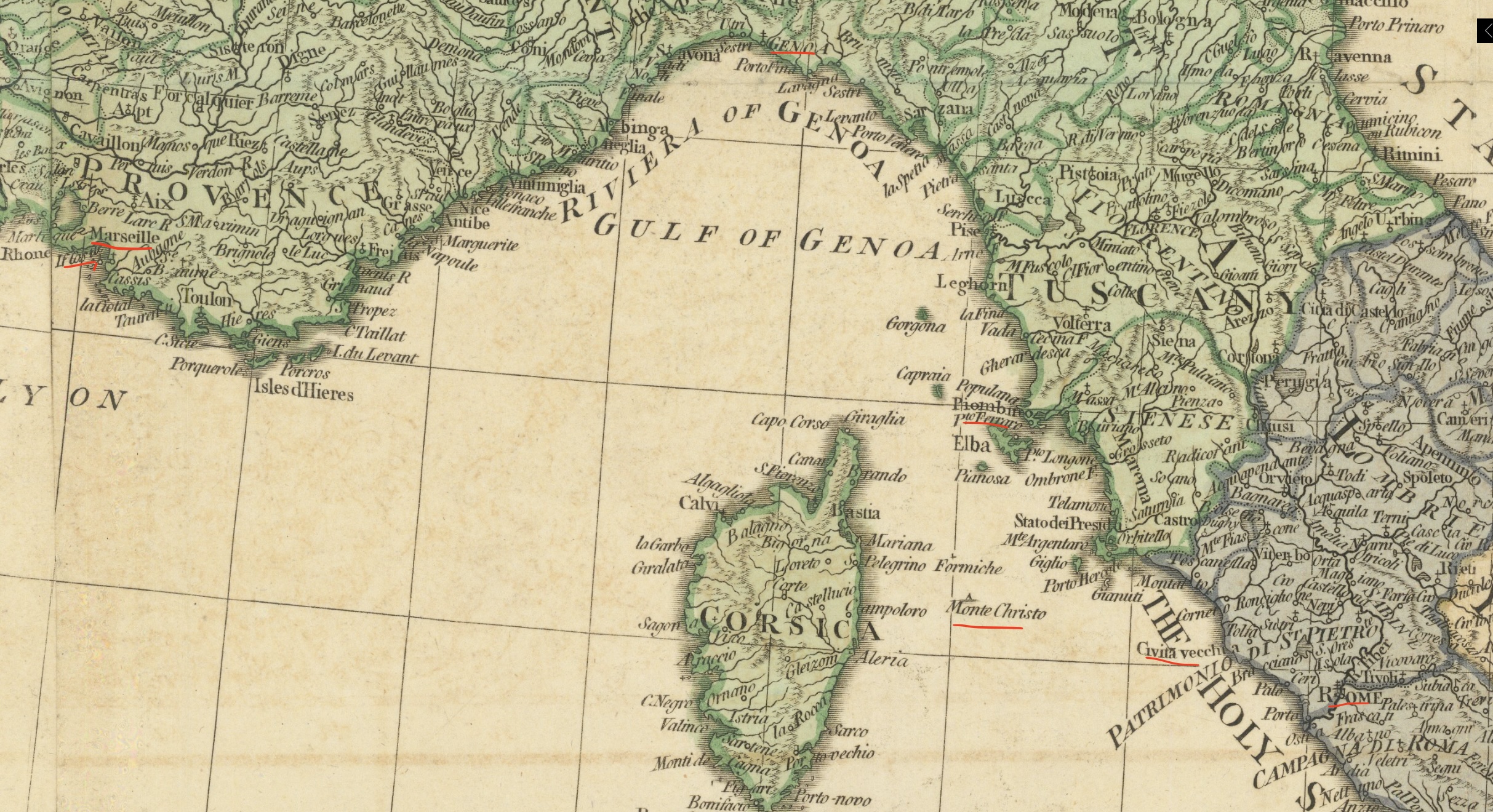
Highlighted are all of the place-names that I can remember, that have some minor or major importance within the book. One thing to note is that the island that Dantès swims to, Tiboulin, is not marked in this map. ALso of curiosity is how Monte Cristo itself is depicted as an unshaded triangle, representive of the fact that it really is just a desolate, granate hill within the Mediterranean Sea. I also somehow remembered to outline Genoa, since that's where Dantès purchases his famous yacht, but forgot to outline Leghorn, which can be easily found between the big "Genoa" and "Tuscany" titles. The other major exception to note is, of course, the absence of Paris, which I couldn't fit in there as it's pretty far north of Marseilles (about five days of travel with a nightky rest-stop for Villefort, if I remember correctly, and is probably much faster now that trains exist.)
Another thing I'm probably going to have to get used to is the speed of travel and information. This thread was pretty useful in determining the nature of the vessel that Dantès purchases in Genoa, and why it would be a pretty useful tool to have for getaways and fanciful adventures. Generlly speaking, I do not enjoy naval history, but I think I have to learn about how boats actually work now...
Sun, 28 Dec 2025 21:35:39 +0500